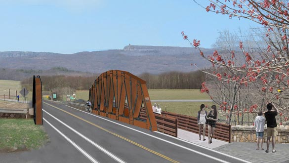
A rendering of the new Carmine Liberta Bridge in New Paltz and the public area where people can appreciate the view and watch the sunset. (provided)
Ulster County Executive Mike Hein confirmed to the New Paltz Times last week that after more than a year of planning, which included several meetings and site visits with a local community Bridge Replacement Advisory Committee, site preparation and construction of the Carmine Liberta Bridge will begin next month, soon after the May 1 New Paltz Regatta. “Don’t ruin the Regatta was one of the many issues we kept in mind as planning for bridge replacement moved forward,” said Hein. “We are excited that we are now about to begin the implementation phase of the project.”
The County Executive’s detailed knowledge of the project was demonstrated during a meeting held at his invitation last week at the County Office Building in Kingston. “The idea of capturing the imagination of the New Paltz community and engaging with the community in a way that government, at least at the county level, has never done before has been my number-one priority since the inception of this project.” Hein said he knew it would require an extraordinary level of communication and coordination with the local community. “What separates this bridge from a whole host of others is the iconic view of the Shawangunks. This may be one of the most beautiful scenic views in upstate New York. We wanted to respect that view and enhance the experience when it became clear the 76-year-old bridge needed to be replaced. We also knew that over 10,000 vehicles cross that bridge every day. and there was no way we were going to force drivers to detour through Rosendale or Gardiner during the projected seven-month construction phase.”
When the replacement project begins, traffic will be routed to a temporary replacement bridge (situated north of the current bridge on the Wallkill). The new Wallkill River bridge will be an arched, Cambridge truss bridge with a weathered, natural steel finish. Lighting for the bridge’s cantilevered sidewalk will be luxrail-style LED handrail lighting. Lighting above the bridge will be minimalistic — not stylistic — and affordable. The total cost is estimated to be approximately $2.5 million. The Town of New Paltz website contains a detailed description of the project and, according to a public notice posted on March 22, 2016, $490,000 of this amount will come from Community Development Block Grant — Disaster Recovery program funding and the balance from local county sources.
Hein was particularly proud of one particular feature of the new bridge. “We are going to create a stone overlook as a free public space where everyone can appreciate the view and watch the beautiful sunsets.” He also took the opportunity to announce publicly for the first time that Route 299 west of the bridge will be widened, with four-foot shoulders on either side, ultimately reaching all the way to Route 44-55. “This will significantly improve safety for drivers, walkers and bikers.”
Electronic and hard signage will be used to keep the public informed. “I believe that the public information aspect of this project is important,” said Hein. “We are committed to the best public outreach and signage that we can provide. Our goal is to have the new bridge open by the end of the year.”
Also present at last week’s meeting was Dennis Doyle, Director of the Ulster County Planning Department, who described the technical challenges that had to be considered. “This is one of the more complicated projects we have ever undertaken. This is not just a bridge for vehicular traffic. The bridge serves as a crossing for critical water service for the Village of New Paltz and for broadband and telephone service for those living west of the Wallkill.”
Hein added, “We saw this as an opportunity to harden the infrastructure and protect these services in light of the new reality of more storms and floods related to climate change issues.”
Sandy Ferrante’s family leases and farms the 15-acre field on the west bank of the Wallkill River owned by the Open Space Institute. He believes that one to two acres of the field will be taken out of production for the temporary bridge access ramps and for equipment storage and staging purposes. He commented, however, that the final result, in addition to showcasing the iconic view when approaching from the east, will also be “an aesthetic improvement for those entering New Paltz from the west.”
A group effort
Hein expressed appreciation for the work of the advisory committee, made up of town and village elected officials; members of the Bike/Pedestrian Committee and the Downtown Business Association; Gail Gallerie, chair of the joint Town/Village Transportation Committee; and Peter and Sandy Ferrante, whose farmland will be impacted by the project. “The committee helped us to plan this project in an integrated way that has never been done before,” said Hein. “This was not just plopping a new steel structure down.” Hein also acknowledged the crucial role that New Paltz and the bridge play in what he referred to as the Ulster County Rail Trail, which will eventually allow pedestrians and bikers to travel from the Walkway Over the Hudson in Highland to the banks of the Ashokan Reservoir at the eastern end of the Catskill Park.
Hein credited the engineers and staff of the Ulster County Department of Public Works (DPW) and the leadership of DPW Commissioner Susan Plonski for developing the plan that will allow traffic to continue across the Wallkill throughout the bridge replacement project. “The typical government project would be to shut down traffic and put up detour signs, with massive disruption to residents, businesses, SUNY New Paltz students, faculty and staff, tourists and critical emergency services. It would be done when it would be done, with no commitment to a completion date. That has been the standard process in government all across our country. There was no way we were going to let that happen in New Paltz. Our answer was, ultimately, a second, temporary bridge that will allow vehicular, pedestrian and bicycle traffic to cross the Wallkill while the old bridge is replaced.”
The County Executive acknowledged that constructing a temporary bridge to the north of the current bridge will add cost to the project. He pointed out, however, that savings in other areas have allowed the county to take on this expense. He also pointed out, “While having a temporary bridge will cost more than not having a temporary bridge, I believe the net cost will be significantly less when you take into account the lost business revenue and the cost to residents and bridge users who would otherwise spend time and fuel being forced miles out of their way during the several months of the bridge replacement project.” He added, “Hats off to Sue Plonski and her team for helping me to keep my promise that not one single bolt of the Carmine Liberta Bridge will be removed until an alternate bridge is up and running.”
Commenting on Hein’s promise, Gallerie said, “I continue to be appreciative of the county’s willingness to replace this aging bridge while it is still safe and before emergency measures might have been needed. I remember when Mike Hein promised our advisory committee that this project would be completed on time and on budget, and that is exactly what seems to be happening.” Gallerie also commented that she was “gratified that this is only the second time in recent history that Ulster County has involved a citizen advisory committee in the planning of a construction project.” The other project is also in New Paltz and will soon result in a widening of South Putt Corners Road to increase the safety of vehicles, pedestrians and bikers.
Village Mayor Tim Rogers echoed the sentiments of many when he said, “I think it’s an exciting project for our community. It is admirable the way the county has worked to dot the I’s and cross the T’s to make sure the inconvenience is kept to a minimum. I’m sure there will be some hiccups, as with any large construction project, and I encourage folks to be patient and focus on the long-term benefits of this important project.”
The new bridge is lovely but if you really want to improve NP, figure out a way to divert heavy traffic from the middle of downtown!
I agree Kathleen. No matter what time of day or what day of the week, the traffic in NP is awful!!
Finally. Hopefully we can also come up with a plan now for a more visually pleasing Main Street. With new side walks and some upgraded building facades like Hudson or Rhinebeck. Let’s not forget the parking.
Very exciting, this is great news. Proud to say our community – town, village, county have come together to make some progress.
With regard to the other comments – I think it would be very compelling for the Town, property owner and prospective developer consider redeveloping the municipal parking lot on Plattekill Avenue across from the
Chase / Village Tea Room.
The idea here would be that this parcel is perfectly sited and the right size to hold a 2-3 level parking deck –
public parking – and would include two retail spaces at street-level facing Plattekill and could even sustain 2-levels of residential above those retail spaces. I am familiar with many communities where this kind of in-fill development alleviates parking issues (this would create 3x the spaces currently available on the surface lot, reduce runoff, etc…many benefits). If you look at the site from a bird’s eye view walking on Plattekill you’d see
a brick building with casement windows, awnings, two retail spaces and two floor so residential above. There would be an entrance approximately where the current entrance is and a ramp down to one level of parking, and
then ramp cup to 2 levels of parking – all of the parking structure would be behind the retail/residential and invisible from the street. The existing retail behind the building would remain as the site would be designed to allow the entrance to those rear buildings. It’s a smart idea if folks could get the parties involved on board. This solution could even provide for the elimination of some spaces on the Main Street squeeze around the corner.
The OTHER thing that would help is a re-think of the crosswalk situation. People aren’t using the crosswalks ‘correctly’ they just walk right into traffic. We need signs and pavement markings at the Main Street crosswalks telling pedestrians to STOP. LOOK. CROSS. (many towns do this) and public education / SUNY education that crosswalks aren’t just for marching into traffic without pausing and looking. It DOES change the flow when people pause before they cross.
This is the type of span that should have been built on Bridge Street in Phoenicia. The above-deck girders prevent the buildup of floodwaters and debris that wrecked town during Hurricane Irene, and would allow the bridge to sit lower without that “hump” it’s got now. Such flooding is what swept away several trailers along Station road, and wrecked the tracks in Phoenicia along with the railroad yard. I’d imagine the backup of water behind the bridge also contributed to flooding to the west as well.
The sidewalk would allow the high volume of traffic that exists from town to the south bank of the creek, which always seemed dangerous as there’s currently nowhere else to go. If the railroad is allowed to continue, passengers from either the depot or Bridge st. stop would likely want to be able to walk safely to town. If the trail gets built, I would think the pedestrian traffic would still be there.
Also, a truss bridge looks much more presentable as the main road into one of the greatest towns in the state. It’s a little more memorable too than an I-beam span