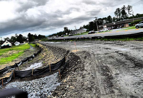
Pictured is a section of the Empire State Trail along Route 299 connecting the Hudson Valley Rail Trail to the Wallkill Valley Rail Trail in the towns of Lloyd and New Paltz. (Lauren Thomas)
Plans to connect the various rail and other walking trails in the area have been given a significant push in the form of the Empire State Trail initiative. Even as construction continues on the extension of the Hudson Valley Rail Trail along Route 299, plans were unveiled last week in the form of an open house to bring that trail into New Paltz on a much shorter schedule. Where the Hudson Valley Rail Trail West was announced in 2015 and is being built three years later, this next section has a planned completion date in 2019.
A bevy of state transportation officials, who are typically very difficult to get into a meeting, were on hand to explain the specifics to all comers. This 1.6-mile section will run along the shoulder of Route 299, with a crossing at Ohioville Road. For that stretch, a barrier between motorized and non-motorized traffic is planned. The trail will go up North Putt Corners Road and along Henry W. Dubois Drive, turn onto Church Street to pick up Mulberry, from whence it will be connected to the Wallkill Valley Rail Trail. Work will begin in August and be substantially done by October 31, with the project complete by the end of May 2019.
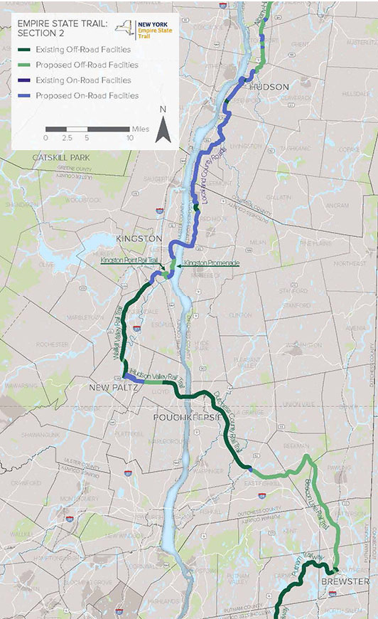
Here’s the route the on-road portion will take through New Paltz:
The link was always planned, but the effort has been given a boost by its inclusion in the 750-mile Empire State Trail, slated for completion in 2020. The “off-road” portion being constructed along Rt. 299 can be seen below in light-green.
Ulster County Executive Mike Hein remarked that he was “amazed at the speed” of this project, which he said was in testament to the fact that “2021 was never going to work,” referring to the originally-planned completion date of this connector. It’s also part of fixing traffic engineering problems of past decades, he said, when it wasn’t anticipated how dominant automobiles would become on the landscape.
Former Town Planning Board chair Mike Calimano, who worked for well over a year to set up a meeting with state roads officials, was clearly impressed by how many had come out to explain this concept.
Not everyone at the open house, held in the New Paltz Community Center, was entirely pleased with the route selected. Peggy Kremer, for one, would have liked to see a longer route that she believes would be a safer one, sending the trail down South Putt Corners Road — where even now, shoulders are being expanded into walking paths — and across Jansen.
Michael Reade, president of the Wallkill Valley Rail Trail Association, said that putting the trail on Dubois and Church is “a bad idea” because of poor lines of sight. He, too, wondered why the Jansen option didn’t rise to the top, noting that it was part of the plan advanced by David Lent when that man was town supervisor.
Former village mayor Tom Nyquist recalled that, when his board decided to acquire the village stretch of the Wallkill Valley Rail Trail, it was on a three-to-two vote. He called this connection a “great idea,” but nevertheless is worried about the trail as it runs along the soon-to-be-built Zero Place along Mulberry Street. That’s because two handicapped spots are planned right there, and he and other neighbors raised the possibility of bicycle/car conflicts during the planning process.
“We would never compromise safety,” said Hein.
That sentiment resonated with what town resident Bob Hughes had to say; he’s “very excited” about the plans, but wants “the gold standard of safety.”
Chris White, who handled the land acquisition negotiations on behalf of the county, said that a longer route would have been much more challenging to achieve.
Get out the ambulances!
The County of Ulster always compromises safety, and that’s just on Mulberry Street and Church. The STOP sign has been down and missing for the last 30 days. Marx drives right by it day after day as it lay in the grass, and all the King’s horses and all the King’s men could not put it back together again.
Sifre, who built Nyquil’s house, never had to put in sidewalks down Henry W, Ruger didn’t have to put in sidewalks on Church and Schoonover didn’t have to put in sidewalks on Mulberry. Are you #$%^($@ kidding me?
The Village of New Paltz owns the triangle of land at Henry W; and Church Street, a parcel that has no sidewalks at all? Didn’t have them when Nyquil was in office in the last century, and here it is, 101 years after World War I ended, and still devoid of pedestrian safety paths. Hine may as well put his name up at the New Paltz Dog Park.
Wait, his name is up at the New Paltz Dog Park.
Yours is a great study in how maps lie. Mulberry Street is but 15′ wide, three feet less than what the town, not the village, requires for a two-lane wide driveway. The sewer line in Mulberry Street, which serves both town and village, is but 4″ in diameter, not 6″ or greater. It is strung together with Ferncos, the last repair having been photographed in 1976. As to the rail-trail itself, in the book WALLKILL VALLEY RAILROAD, Nyquil is quoted as saying that the line was purchased not for a linear park, but to run sewer lines in. When Zitfree put in 54 apartments on Mulberry Street, that is just how and where the connections were made. Then, he built the mayor’s house at what cost nobody knows yet. The grant writer for the village now is the head of the village planning board,Burgler, the planning board of the village is made up of landlords, and the town’s Board of Assessment Review owns 35 rental properties between them on this route, with no sidewalks for pedestrians, and no money for a professional emergency services fire department, which is controlled by the village b lard as de facto fire commissioners, the head of which, mayor Captain Buck Rogers, runs and illegal boarding house. you’d think that Hine would call in the IRS to get the money required from these capitalists for recreation fees, all forgiven by the village planning board, income capitalized commercial lodging services under the name of public safety. Id like to see them all take a walk in the street down Henry W. Church and Mulberry without getting hit by cars and bikes and motorcycles or take a run for safety.
Lots of work going on. Love the Walkway.
Its so expensive to live in New York that people don’t have time to go walk on a trail. So instead of making tax cuts the state decides to spend more money on useless projects forcing you to work more hours to pay higher taxes and leaves you no time to walk on the trail.
The crossing along 299 over the Thruway needs to be designed and built as a separated road surface on its own bridge. I’d place a single steel span truss bridge (a larger version of what we see on the West Slope of
Mohonk Road. They’re easy to install and this will eliminate ALL concerns about the squeeze for walkers and
bikers along 299 on the existing bridge.
Let’s not cheap out on this portion – we’ve come this far – taking the lazy route on the last section will only
be failure.